
Model differences ??? 500HO VS 500L
I have a 96 sportsman 500L What does the L mean ??? What makes a 500 HO ???
Thks
Angelo
Tread Lightly! AZ Trail Clean Up in the Sonoran Desert Nat’l Monument (4/25/15)
Last month we partnered with Tread Lightly! on a project to clean up Table Mesa Recreation Area where 250 volunteers showed up, in the rain,
to pick up trash. Together we removed more than 10 tons of trash from the area! Click HERE to see more about our day cleaning up Table Mesa.
to pick up trash. Together we removed more than 10 tons of trash from the area! Click HERE to see more about our day cleaning up Table Mesa.
Tread Lightly! is back at it and is hosting another trail clean up day on Saturday, April 25th, 2015 in the Southwest Valley. This is another step
toward keeping our Arizona off-road recreation access open. Please share this info with your family and friends. The more people that help, the
more that can be done. See the information below for more details.

We need your help!
Join us for a stewardship event on the Sonoran Desert National Monument.
Every Volunteer Counts!
Please bring water, work gloves, hat, sunscreen, trash pinchers, buckets and wear long pants and sturdy shoes. 4WD and OHV vehicles are useful.
- When: Saturday, April 25th, 2015
- Time: 7:30am-12:00pm (Check-in starts at 7:30)
- Where: Gas line/ Power line Road in the Sonoran Desert Nat’l Monument
- RSVP: Sign up online at: http://tinyurl.com/sonorancleanup
- Directions: The area is off of the Gasline/Powerline road that runs along the north side of the N. Maricopa Mountains and is the Northern boundary for the monument.
From Maricopa: (High Clearance vehicles only. Drive will take about 50 minutes to 1 hour from Maricopa to Project Site)
Take Hwy 238 (SR 347 and Smith-Enke/Route 238) west appx. 12.5 miles to Mobile Elementary School at 99th Ave. (between MP 31 and 30). Turn right on 99th Ave. at the school. Drive a short distance. FOLLOW THE ORANGE FLAGGING TO THE LEFT AT THE ROAD FORK; cross cattlegaurd. You are now on the Gasline/Powerline road (aka Komatke Rd). CONTINUE FOLLOWING THE FLAGGING. Continue northwest 5.7 miles along Gasline/Powerline road. Road narrows, cross cattleguard, continue straight on well-graded road 1.3 miles; road curves to right. Continue another 1.3 miles north on graded road (Bullard Ave.) and turn left back onto gasline/powerline road. Drive another 5.2 miles northwest along gasline/powerline road to Project Site/Sign-In Table.
From West Valley Area (Buckeye/Goodyear/Avondale): Drive will take about 30-40 minutes.
Eastbound I-10: Take I-10 East to Exit 123, Citrus Rd/Cotton Ln (West of Loop 303 Interchange.) Drive East on frontage road to Cotton Ln. Turn Right on Cotton Ln.
Westbound I-10: Take I-10 West to Exit 125, Sarival Ave/Cotton Ln (East of Loop 303.) Drive West onI-10 frontage road to Cotton Ln. Turn Left on Cotton Ln.
Once on Cotton Ln, drive South about 6.5 miles to Estrella Pkwy Roundabout. Turn Right on Estrella Pkwy Roundabout; stay on Estrella Pkwy and drive South appx. 3.5 miles to Willis Rd (4-Way Stop). Turn Right on Willis Rd, drive West 1.5 miles to Rainbow Valley Rd. Turn Left on Rainbow Valley Rd and drive South appx. 7 miles. Rainbow Valley Rd ends. FOLLOW ORANGE FLAGGING, and drive the far right two-track dirt road South about ½ mile to the Gasline/ Powerline road and Project Site/Sign-In Table.
- Questions: Contact Dianne Olson at dianne@treadlightly.org or 800-966-9900 ext. #13
Ontario ATVers Beware
Here’s an incredibly disturbing letter from the Resource Management Supervisor of MNR Bracebridge Field Office sent to HATVA’s associate Lake of Bays ATV club (LOB). Basically, in Ms. Collins opinion there are no bush trails on any of the Crown lands that have been used and signed by the LOB club. If this letter reflects the Minister’s stance it spells the end of ATVing in Ontario. LOB was told all lumber roads, including overgrown ones, are considered Highways and ATV use is prohibited; if a trail appears on any map it is considered a road. LOB now has no trails.
If this insanity spreads there will be no where to ride in Northern Ontario and will shut down many of the southern Ontario clubs. For example, HATVA’s 1700 km of bush trails (with the exception of the Rail Trails and a few private properties) all fall on Crown land.
In April 2013 LOB received a letter from the MNR office allowing them to place trail signage, now the same office wants the signs removed. HATVA feels trail signage is necessary, not only to identify the route where you are travelling but also to identify position in the event of emergencies.
We can only hope the long awaited changes Highway Traffic Act will clarify exactly what is considered a highway. Until then I suppose it’s okay to weave through the trees on Crown land as long as you’re not leaving a trail behind you. In this matter, I suspect someone has made a decision far above their pay grade.
Tread Lightly! AZ Trail Clean Up in the Sonoran Desert Nat’l Monument (4/25/15)
Last month we partnered with Tread Lightly! on a project to clean up Table Mesa Recreation Area where 250 volunteers showed up, in the rain,
to pick up trash. Together we removed more than 10 tons of trash from the area! Click HERE to see more about our day cleaning up Table Mesa.
to pick up trash. Together we removed more than 10 tons of trash from the area! Click HERE to see more about our day cleaning up Table Mesa.
Tread Lightly! is back at it and is hosting another trail clean up day on Saturday, April 25th, 2015 in the Southwest Valley. This is another step
toward keeping our Arizona off-road recreation access open. Please share this info with your family and friends. The more people that help, the
more that can be done. See the information below for more details.
We need your help!
Join us for a stewardship event on the Sonoran Desert National Monument.
Every Volunteer Counts!
Please bring water, work gloves, hat, sunscreen, trash pinchers, buckets and wear long pants and sturdy shoes. 4WD and OHV vehicles are useful.
- When: Saturday, April 25th, 2015
- Time: 7:30am-12:00pm (Check-in starts at 7:30)
- Where: Gas line/ Power line Road in the Sonoran Desert Nat’l Monument
- RSVP: Sign up online at: http://tinyurl.com/sonorancleanup
- Directions: The area is off of the Gasline/Powerline road that runs along the north side of the N. Maricopa Mountains and is the Northern boundary for the monument.
From Maricopa: (High Clearance vehicles only. Drive will take about 50 minutes to 1 hour from Maricopa to Project Site)
Take Hwy 238 (SR 347 and Smith-Enke/Route 238) west appx. 12.5 miles to Mobile Elementary School at 99th Ave. (between MP 31 and 30). Turn right on 99th Ave. at the school. Drive a short distance. FOLLOW THE ORANGE FLAGGING TO THE LEFT AT THE ROAD FORK; cross cattlegaurd. You are now on the Gasline/Powerline road (aka Komatke Rd). CONTINUE FOLLOWING THE FLAGGING. Continue northwest 5.7 miles along Gasline/Powerline road. Road narrows, cross cattleguard, continue straight on well-graded road 1.3 miles; road curves to right. Continue another 1.3 miles north on graded road (Bullard Ave.) and turn left back onto gasline/powerline road. Drive another 5.2 miles northwest along gasline/powerline road to Project Site/Sign-In Table.
From West Valley Area (Buckeye/Goodyear/Avondale): Drive will take about 30-40 minutes.
Eastbound I-10: Take I-10 East to Exit 123, Citrus Rd/Cotton Ln (West of Loop 303 Interchange.) Drive East on frontage road to Cotton Ln. Turn Right on Cotton Ln.
Westbound I-10: Take I-10 West to Exit 125, Sarival Ave/Cotton Ln (East of Loop 303.) Drive West onI-10 frontage road to Cotton Ln. Turn Left on Cotton Ln.
Once on Cotton Ln, drive South about 6.5 miles to Estrella Pkwy Roundabout. Turn Right on Estrella Pkwy Roundabout; stay on Estrella Pkwy and drive South appx. 3.5 miles to Willis Rd (4-Way Stop). Turn Right on Willis Rd, drive West 1.5 miles to Rainbow Valley Rd. Turn Left on Rainbow Valley Rd and drive South appx. 7 miles. Rainbow Valley Rd ends. FOLLOW ORANGE FLAGGING, and drive the far right two-track dirt road South about ½ mile to the Gasline/ Powerline road and Project Site/Sign-In Table.
- Questions: Contact Dianne Olson at dianne@treadlightly.org or 800-966-9900 ext. #13
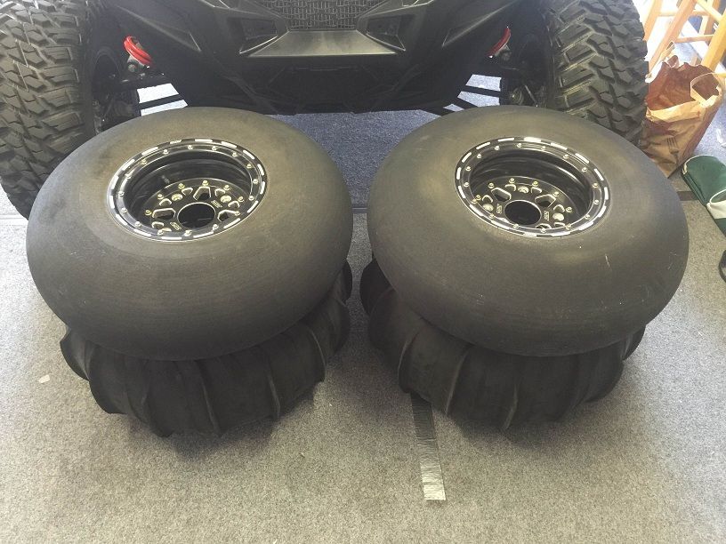
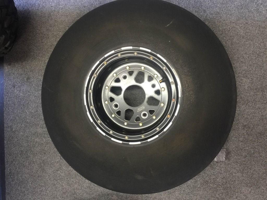
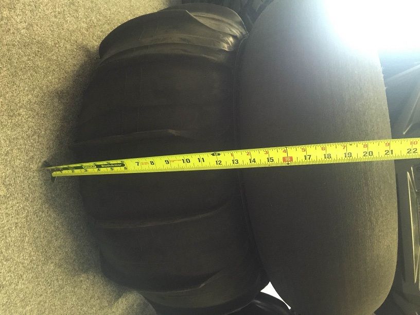
Paddle Tires & Stock Rears
Paddle Tires are Sand Tires Unlimited Sand Blaster 26 with front smoothies mounted on Douglas DWT Sector Beadlocks. This setup is a little over $2000 new and have been used a couple times. These came with my used rzr purchase and I will not be needing them. $1600 obo
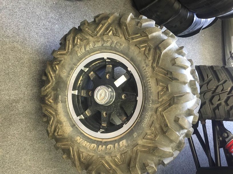
Stockers are rears only with big horn 26x12x12. $175 obo
I live in South Orange County but do go all over the county for work and will deliver if you are not in a rush. No shipping. I rotated the photos but for some reason photobucket turned some of them back to sideways when I uploaded so turn your neck if need be.
PM me or text me at 949-584-0035.
Eric


Polaris black crusher rims & Baja Cross tires
Polaris factory black crusher rear wheels $40.00/wheel
ITP Baja Cross Tires 26x11R12 $50.00/Tire


Polaris black crusher rims & Baja Cross tires
Polaris factory black crusher rear wheels $40.00/wheel
ITP Baja Cross Tires 26x11R12 $50.00/Tire
WTB- HCR boxed high clearance radius rods
For 900 XP. Looking for matte black 4 piece set shipped to 98004. Thanks!